Pembrokeshire Coast Path: Section by Section
The Pembrokeshire Coast Path: it’s 186 miles of stunning Welsh coastline, but tackling it all at once isn’t for the faint of heart. This guide breaks down the path into manageable sections, offering honest advice and practical tips to help you plan your hike.
Pembrokeshire Coast Path: Section by Section
So, you’re thinking about the Pembrokeshire Coast Path, are you? Good on you. It’s a stunner, no doubt, but let’s be straight – it's not always a walk in the park. This isn't some manicured, flat promenade. We're talking proper coastal hiking, with all the ups and downs, mud, and unpredictable weather that comes with it. I’ve walked most of it over the years, and learned a few things along the way, so I'm going to share the wisdom – section by section.
Before You Go: The Essentials
First things first: preparation. The Pembrokeshire weather laughs in the face of forecasts. Pack for all seasons, even in July. Decent waterproofs are non-negotiable. Trust me on this. Footwear? Sturdy hiking boots, broken in beforehand, are essential. An OS Explorer OL35 map is a good idea, though the path is generally well-marked. Mobile signal can be patchy, so don't rely solely on your phone. Public transport is available, but can be infrequent, especially outside peak season. Plan your stages accordingly. Consider a baggage transfer service if you're doing a multi-day hike – there are a few companies that operate in the area. Finally, book accommodation well in advance, especially during the summer months. Places like St Davids and Tenby fill up fast.
Section 1: Amroth to Tenby (approx. 8 miles)
This is a relatively gentle introduction, perfect for easing yourself in. The path winds along the cliffs, with views over Carmarthen Bay. You'll pass through Wiseman's Bridge and Saundersfoot – both good spots for a cuppa. Parking in Amroth can be tricky in the summer; arrive early or use the park-and-ride service. The terrain is mostly well-maintained, but there are a few short, steep climbs. This section is manageable for most reasonably fit hikers, and family-friendly in good weather. Consider a detour onto the beach at Tenby for a paddle. You could even book a Coasteering session with Tenby Adventure for around £60.
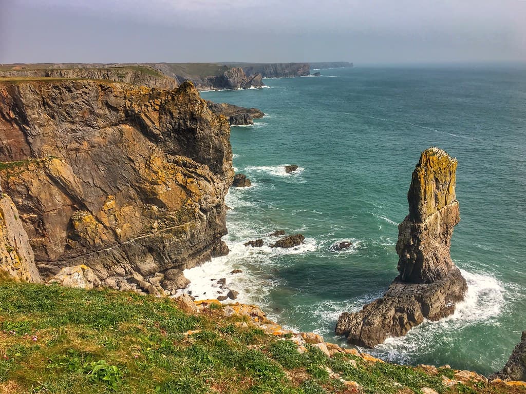
Section 2: Tenby to Stackpole Quay (approx. 14 miles)
This is where things start to get a bit more interesting. This section includes some challenging ascents and descents, particularly around Lydstep Head. The views, however, are spectacular, especially from the top of the cliffs. You'll pass through the iconic Barafundle Bay – regularly voted one of the best beaches in the UK, and rightly so. Parking is available at Stackpole Quay, but it can get very busy. This section is best suited to experienced hikers with a good level of fitness. Not one for those with vertigo, as some parts are quite exposed. For a detour, consider a Wild Swimming session at Broad Haven South with Preseli Venture, from around £45.
Section 3: Stackpole Quay to Angle (approx. 12 miles)
This section offers a mix of coastal scenery and inland walking. You’ll pass through the Bosherston Lily Ponds – a series of man-made lakes that are home to a variety of wildlife. The path then follows the coastline around to Angle, a charming village with a pub (the Hibernia Inn) and a lifeboat station. Parking is available in Angle, but again, it can be limited. This section is moderately challenging, with some steep climbs and descents. Suitable for hikers with a reasonable level of fitness.
Section 4: Angle to Pembroke (approx. 10 miles)
This leg involves more inland walking, following the Pembroke River. You’ll pass through Pembroke Dock, a former Royal Naval dockyard. This section is less scenic than some of the others, but it’s a good option if the weather is bad, as it’s more sheltered. Parking is available in Pembroke. This section is relatively easy, and suitable for families with older children. Pembroke Castle is well worth a visit – allow at least a couple of hours.
Section 5: Pembroke to Neyland (approx. 12 miles)
Another stretch with significant inland portions. This follows the river, and although lacking the dramatic cliffs, it’s a more sheltered section. This could be a good choice in poor weather. Neyland has a marina and some amenities. Parking is available, and the route is relatively flat. It’s a good option for those who prefer an easier walk.
Section 6: Neyland to Dale (approx. 14 miles)
Back to the coast! Dale is a picturesque village with a sheltered bay that’s popular for watersports. You'll find parking available, but can be limited in peak season. This section offers good views across to Dale and out to Skomer Island (worth a boat trip if you have the time, to see the puffins). Expect moderate difficulty with some climbs. You might see TYF Adventure running Sea Kayaking sessions from Dale, with prices starting around £60.
Section 7: Dale to Marloes Sands (approx. 7 miles)
A shorter section but not necessarily easier. Marloes Sands is another stunning beach, and has been used in several films. This is a more exposed section of the path. Parking available. Moderate difficulty.
Section 8: Marloes Sands to Little Haven (approx. 10 miles)
This section takes you past St Bride’s Bay, and offers beautiful coastal views. Little Haven is a small village with a couple of pubs. This section is moderately challenging, with some steep climbs. Parking available.
Section 9: Little Haven to Broad Haven (approx. 8 miles)
Expect some climbing as you go past Settlands Head. Broad Haven is a popular spot. Parking is available, though can be full in summer. The path is generally well-maintained, moderate difficulty.
Section 10: Broad Haven to Newgale (approx. 6 miles)
This is a shorter section, but includes some of the most dramatic coastal scenery on the Pembrokeshire Coast Path. You’ll pass the iconic rock formations of The Druidston and the Marloes Peninsula. Newgale is a long, sandy beach that’s popular with surfers. The road runs right alongside the beach, so this can be a good place to finish up. Easy to moderate. Consider stopping at Outer Reef Surf School in Newgale for a Surfing lesson, expect to pay around £55.
Section 11: Newgale to Solva (approx. 8 miles)
This stretch is known for its rugged coastline and dramatic cliffs. Solva is a charming village with a picturesque harbour. This section is challenging, with some steep climbs and descents. Parking can be tricky.
Section 12: Solva to St Davids (approx. 7 miles)
This section takes you past St Non's Bay, the birthplace of St David, the patron saint of Wales. St Davids is the smallest city in the UK, and is home to a magnificent cathedral. Parking is available in St Davids, but can be expensive. This section is moderately challenging, with some steep climbs. A visit to the cathedral is a must. You could take a boat trip from St Davids to Ramsey Island – Preseli Venture runs tours from £45.
Section 13: St Davids to Whitesands Bay (approx. 3 miles)
A short but satisfying section, and you’ll pass some wonderful coastal scenery. Whitesands Bay is a great surfing beach. Parking is available but is pay and display. This is a perfect easy section for families.
Section 14: Whitesands Bay to Porthgain (approx. 8 miles)
This is another challenging section, with some steep climbs and descents. Porthgain is a small harbour village with a pub (The Sloop Inn) and a cafe. Parking can be difficult in summer.
Section 15: Porthgain to Fishguard (approx. 13 miles)
One of the longer sections. Fishguard is a larger town with more facilities. This is a challenging section, with some steep climbs. Parking available in Fishguard.
Alternatives: Inland Options
Let’s be honest, the coast path isn’t always the best option. If the weather is truly awful, or you fancy a change of scenery, consider exploring some of the inland areas of Pembrokeshire. The Preseli Hills offer fantastic views and a chance to escape the crowds. There are several well-marked trails, ranging from easy strolls to challenging hikes. You could even combine a walk with a visit to one of the area's ancient sites, such as Pentre Ifan burial chamber. And remember, further north you've got Snowdonia, with a whole different scale of challenge and beauty on offer.
Final Thoughts
Walking the Pembrokeshire Coast Path is an incredible experience. It’s challenging, rewarding, and offers some of the best coastal scenery in the UK. With careful planning and preparation, it’s an adventure that you’ll never forget. Now get out there, and enjoy it!